Barrier ID | Internal Name | Structure Status | UTM Zone | UTM Easting | UTM Northing | CWF Model Rank (Spawning Habitat) | CWF Model Rank (Rearing Habitat) | Average Spawning Habitat Upstream of Structure (km) | Actual Spawning Habitat Upstream of Structure (km) | Average Rearing Habitat Upstream of Structure (km) | Actual Rearing Habitat Upstream of Structure (km) |
|---|---|---|---|---|---|---|---|---|---|---|---|
57944 | Toboggan Cr @ Hwy 16 (57944) | Non-actionable barrier | 9 | 607729 | 6089383 | 1 | 1 | 18.3200000 | 18.32 | 23.690000 | 23.69 |
1024756616 | Sinclair Cr @ Telkwa R FSR (24756616) | 9 | 596354 | 6053671 | 2 | 4 | 12.3400000 | 12.34 | 16.370000 | 16.37 | |
123770 | John Brown Cr @ Hwy 16 (123770) | Data-deficient barrier | 9 | 606627 | 6097184 | 3 | 5 | 11.7600000 | 11.76 | 15.900000 | 15.90 |
197663 | Johnny David Cr @ Hwy 16 (197663) | Data-deficient barrier | 9 | 670241 | 6044772 | 4 | 3 | 10.2800000 | 10.28 | 18.320000 | 18.32 |
197960 | Corya Cr @ Railway (197960) | Priority barrier | 9 | 605806 | 6099877 | 5 | 10 | 9.0900000 | 9.09 | 12.360000 | 12.36 |
197976 | Ailport Cr @ Hwy 16 (197976) | Data-deficient barrier | 9 | 680645 | 6039756 | 6 | 6 | 4.8300000 | 0.40 | 9.620000 | 0.40 |
197975 | Ailport Cr @ Private (197975) | Priority barrier | 9 | 680831 | 6040045 | 6 | 6 | 4.8300000 | 9.26 | 9.620000 | 18.84 |
197662 | Richfield Cr @ Hwy 16 (197662) | Priority barrier | 9 | 672404 | 6044146 | 7 | 8 | 7.6600000 | 7.66 | 13.830000 | 13.83 |
197964 | Bulkley R @ Railway (197964) | Data-deficient barrier | 9 | 691208 | 6031460 | 8 | 2 | 6.2700000 | 7.38 | 18.595000 | 19.58 |
197967 | Taman Cr @ Hwy 16 (197967) | Rehabilitated barrier | 9 | 692434 | 6032341 | 8 | 2 | 6.2700000 | 5.16 | 18.595000 | 17.61 |
58242 | Kathlyn Cr @ Hwy 16 (58242) | Data-deficient barrier | 9 | 616947 | 6073197 | 9 | 14 | 3.5950000 | 3.22 | 4.310000 | 4.31 |
58271 | Kathlyn Cr @ Henry Rd (58271) | 9 | 615887 | 6074598 | 9 | 62 | 3.5950000 | 3.97 | 2.805000 | 2.31 | |
197658 | Byman Cr @ Hwy 16 (197658) | Priority barrier | 9 | 666847 | 6044305 | 10 | 23 | 4.9900000 | 4.99 | 5.300000 | 5.30 |
123377 | Thompson Cr @ Walcott Rd (123377) | Priority barrier | 9 | 641633 | 6049398 | 11 | 26 | 1.7100000 | 1.71 | 2.188000 | 1.70 |
124487 | Porphry Cr @ Hwy 16 (124487) | Priority barrier | 9 | 603073 | 6113379 | 12 | 22 | 4.9900000 | 4.99 | 5.710000 | 5.71 |
198090 | Cesford Cr @ Raiway (198090) | Data-deficient barrier | 9 | 673247 | 6043223 | 13 | 21 | 2.3500000 | 2.35 | 2.450000 | 2.45 |
124420 | Station Cr @ Hwy 16 (124420) | Priority barrier | 9 | 586632 | 6122395 | 14 | 19 | 3.7100000 | 3.71 | 5.910000 | 5.91 |
197668 | Coffin Cr @ Railway (197668) | Data-deficient barrier | 9 | 634351 | 6054625 | 15 | 12 | 1.6033333 | 0.04 | 1.676667 | 0.05 |
124504 | Coffin Cr @ Lawson Rd (124504) | Data-deficient barrier | 9 | 634330 | 6054584 | 15 | 12 | 1.6033333 | 2.16 | 1.676667 | 2.15 |
195476 | Coffin Cr @ Hydro ROW (195476) | 9 | 634279 | 6052600 | 15 | 12 | 1.6033333 | 2.61 | 1.676667 | 2.83 | |
58067 | Gramophone Cr @ Telkwa High Rd (58067) | Priority barrier | 9 | 609735 | 6092894 | 16 | 32 | 3.3600000 | 3.36 | 3.420000 | 3.42 |
57793 | Vallee Cr @ Walcott Rd (57793) | Data-deficient barrier | 9 | 641467 | 6044065 | 17 | 18 | 1.7800000 | 1.78 | 5.590000 | 5.59 |
58208 | Schippers Cr @ Branch off of Kitsequecla Rd (58208) | 9 | 603056 | 6089058 | 18 | 41 | 1.3900000 | 1.39 | 2.560000 | 2.56 | |
58285 | Wiggs Cr @ Private (58285) | 9 | 609106 | 6093156 | 19 | 64 | 1.0350000 | 0.74 | 1.165000 | 0.74 | |
58068 | Trib to Gramophone CR @ Telkwa High Rd (58068) | 9 | 609660 | 6093553 | 19 | 64 | 1.0350000 | 1.33 | 1.165000 | 1.59 | |
3138 | McQuarrie Cr @ North Rd (3138) | 9 | 656523 | 6048132 | 20 | 16 | 1.1400000 | 1.14 | 7.870000 | 7.87 | |
123375 | Trib to Thompson Cr @ Hwy 16 (123375) | Non-actionable barrier | 9 | 642498 | 6048199 | 21 | 26 | 1.5225000 | 0.49 | 2.188000 | 0.50 |
123380 | Trib to Thompson Cr @ Private (123380) | 9 | 642972 | 6048230 | 21 | 26 | 1.5225000 | 1.58 | 2.188000 | 1.58 | |
1001802267 | Thompson Cr @ unnamed (1802267) | 9 | 644009 | 6047451 | 21 | 26 | 1.5225000 | 2.11 | 2.188000 | 2.10 | |
123382 | Trib to Thompson Cr @ McNeil Rd (123382) | 9 | 644704 | 6045590 | 21 | 26 | 1.5225000 | 1.91 | 2.188000 | 5.06 | |
195332 | Trib to Bulkley R @ Unnamed (195332) | 9 | 604923 | 6116233 | 22 | 96 | 1.1300000 | 1.13 | 1.130000 | 1.13 | |
197640 | Trib to Buck Cr @ Buck Flats Rd (197640) | Priority barrier | 9 | 654312 | 6012383 | 23 | 20 | 1.1200000 | 1.12 | 6.150000 | 6.15 |
58158 | McDowell Cr @ Hwy 16 (58158) | Data-deficient barrier | 9 | 628037 | 6060541 | 24 | 47 | 0.5633333 | 0.30 | 0.978000 | 0.30 |
58159 | McDowell Cr @ Private (58159) | Rehabilitated barrier | 9 | 627642 | 6060449 | 24 | 47 | 0.5633333 | 0.45 | 0.978000 | 0.45 |
197912 | Robert Hatch Cr @ Private (197912) | Rehabilitated barrier | 9 | 670963 | 6046221 | 25 | 57 | 2.8000000 | 2.80 | 8.980000 | 8.98 |
198048 | Cesford Cr @ Hwy 15 (198048) | Data-deficient barrier | 9 | 674396 | 6043432 | 26 | 58 | 1.8250000 | 0.67 | 5.555000 | 0.68 |
198049 | Cesford Cr @ Hwy 118 (198049) | Priority barrier | 9 | 674875 | 6043782 | 26 | 58 | 1.8250000 | 2.98 | 5.555000 | 10.43 |
197664 | Barren Cr @ Hwy 16 (197664) | Priority barrier | 9 | 660455 | 6037919 | 28 | 88 | 2.6700000 | 2.67 | 2.670000 | 2.67 |
124500 | Helps Cr @ Lawson Rd (124500) | Priority barrier | 9 | 627541 | 6058702 | 32 | 9 | 0.8400000 | 0.84 | 9.980000 | 9.98 |
197665 | Barren Cr @ Railway (197665) | Priority barrier | 9 | 660628 | 6037843 | 34 | 147 | 0.2700000 | 0.27 | 0.260000 | 0.26 |
1f365462-063c-491e-9fb3-bfac004d9183 | Coffin Cr Dam | Data-deficient barrier | 9 | 634763 | 6051171 | 36 | 12 | 0.9000000 | 0.90 | 4.017500 | 11.04 |
1001800865 | Trib to Sunsets Cr @ Unnamed (1800865) | 9 | 606787 | 6038690 | 38 | 7 | 0.3700000 | 0.37 | 15.100000 | 15.10 | |
58245 | Simpson Cr @ Lake Kathlyn Rd (58245) | Data-deficient barrier | 9 | 615328 | 6075075 | 43 | 171 | 0.2916667 | 0.04 | 0.320000 | 0.04 |
203126 | Simpson Cr @ Private (203126) | Data-deficient barrier | 9 | 615299 | 6075101 | 43 | 171 | 0.2916667 | 0.39 | 0.320000 | 0.39 |
203122 | Simpson Cr @ Railway (203122) | Data-deficient barrier | 9 | 614948 | 6075227 | 43 | 171 | 0.2916667 | 0.72 | 0.320000 | 0.90 |
197974 | Watson Cr @ Hwy 16 (197974) | Data-deficient barrier | 9 | 680390 | 6040069 | 11 | 0.0000000 | 0.00 | 7.040000 | 1.96 | |
198065 | Watson Cr @ Montgomery Rd (198065) | Data-deficient barrier | 9 | 680197 | 6041646 | 11 | 0.0000000 | 0.00 | 7.040000 | 12.12 | |
123445 | Tyhee Cr @ Hwy 16 (123445) | Priority barrier | 9 | 627236 | 6061461 | 13 | 0.0000000 | 0.00 | 5.925000 | 0.49 | |
123446 | Tyhee Cr @ Tyhee Ld Rd (123446) | Non-actionable barrier | 9 | 627516 | 6061772 | 13 | 0.0000000 | 0.00 | 5.925000 | 11.36 | |
197653 | Perow Cr @ Perow Loop Rd (197653) | Data-deficient barrier | 9 | 665518 | 6044200 | 17 | 0.0000000 | 0.00 | 7.380000 | 7.38 | |
195943 | Stock Cr @ Barrett Stn Rd (195943) | Priority barrier | 9 | 645444 | 6035049 | 24 | 0.0000000 | 0.00 | 2.640000 | 0.76 | |
195944 | Stock Cr @ Hwy 16 (195944) | Priority barrier | 9 | 645982 | 6035606 | 24 | 0.0000000 | 0.00 | 2.640000 | 7.11 | |
3139 | Trib to McQuarrie @ North Rd (3139) | Data-deficient barrier | 9 | 656651 | 6048543 | 25 | 0.0000000 | 0.00 | 5.050000 | 5.05 | |
195290 | Gibson Cr @ Hwy 16 (195290) | Priority barrier | 9 | 640022 | 6051682 | 29 | 0.0000000 | 0.00 | 2.260000 | 1.24 | |
195288 | Gibson Cr @ Schnider Rd (195288) | Priority barrier | 9 | 640930 | 6051567 | 29 | 0.0000000 | 0.00 | 2.260000 | 3.28 | |
123777 | Graphite Cr @ Campbell Rd (123777) | Data-deficient barrier | 9 | 607136 | 6101121 | 46 | 0.0000000 | 0.00 | 1.097500 | 0.02 | |
199463 | Graphite Cr @ Campbell Rd (199463) | Data-deficient barrier | 9 | 607116 | 6101128 | 46 | 0.0000000 | 0.00 | 1.097500 | 0.06 | |
123775 | Witset Cr @ Hwy 16 (123775) | Non-actionable barrier | 9 | 606445 | 6099726 | 49 | 0.0000000 | 0.00 | 1.210000 | 1.21 | |
197646 | Trib to Buck Cr @ Spur off Parrot FSR (197646) | Data-deficient barrier | 9 | 672023 | 6005200 | 77 | 0.0000000 | 0.00 | 1.330000 | 1.33 | |
3054 | Johnny David Cr @ North Rd FSR (3054) | Data-deficient barrier | 9 | 664884 | 6052690 | 80 | 0.0000000 | 0.00 | 2.020000 | 1.04 | |
199457 | Glass Cr @ Private (199457) | Data-deficient barrier | 9 | 613248 | 6081291 | 81 | 0.0000000 | 0.00 | 1.035000 | 0.06 | |
199458 | Glass Cr @ Private (199458) | Data-deficient barrier | 9 | 613283 | 6081246 | 81 | 0.0000000 | 0.00 | 1.035000 | 1.62 | |
197656 | Trib to Bulkley R @ Hwy 16 (197656) | Data-deficient barrier | 9 | 663328 | 6042066 | 87 | 0.0000000 | 0.00 | 0.850000 | 0.04 | |
199455 | Trib to Old Woman Cr @ Conrad Lk FSR (199455) | Data-deficient barrier | 9 | 688086 | 6037493 | 90 | 0.0000000 | 0.00 | 2.620000 | 2.62 | |
199452 | Taman Cr @ Taman Cr FSR (199452) | Data-deficient barrier | 9 | 691405 | 6036231 | 102 | 0.0000000 | 0.00 | 1.275000 | 2.18 | |
199448 | Trib to Klo Cr @ Klo Cr FSR (199448) | Priority barrier | 9 | 668634 | 6021387 | 109 | 0.0000000 | 0.00 | 0.930000 | 0.93 | |
198044 | Trib to Toboggan Cr @ Railway (198044) | Data-deficient barrier | 9 | 610393 | 6084973 | 114 | 0.0000000 | 0.00 | 0.925000 | 0.13 | |
124424 | Trib to Waterfall Cr @ Railway (124424) | Data-deficient barrier | 9 | 589483 | 6122989 | 185 | 0.0000000 | 0.00 | 0.347500 | 0.05 | |
124421 | Trib to Waterfall Cr @ 11th Ave (124421) | Priority barrier | 9 | 589467 | 6123041 | 185 | 0.0000000 | 0.00 | 0.347500 | 0.13 | |
124422 | Trib to Waterfall Cr @ Hwy 16/10th Ave (124422) | Data-deficient barrier | 9 | 589500 | 6123161 | 185 | 0.0000000 | 0.00 | 0.347500 | 0.31 | |
199450 | Trib to Klo Cr @ Equity Mine FSR (199450) | Data-deficient barrier | 9 | 666891 | 6019033 | 243 | 0.0000000 | 0.00 | 0.020000 | 0.02 | |
123778 | Graphite Cr @ Hwy 16 (123778) | Data-deficient barrier | 9 | 605388 | 6103278 | 265 | 0.0000000 | 0.00 | 0.080000 | 0.08 |
Current Connectivity Status
The Planning Team identified two Key Ecological Attributes (KEAs) to assess the current connectivity status of the watershed for each focal species: available spawning habitat and available rearing habitat (Table 8). KEAs are the key aspects of anadromous salmon habitat that are being targeted by this WCRP. For each KEA, an associated indicator was assigned to measure the status of that KEA. The connectivity status indicators were used to establish goals to improve key habitat connectivity over time and is the baseline against which progress is tracked over time.
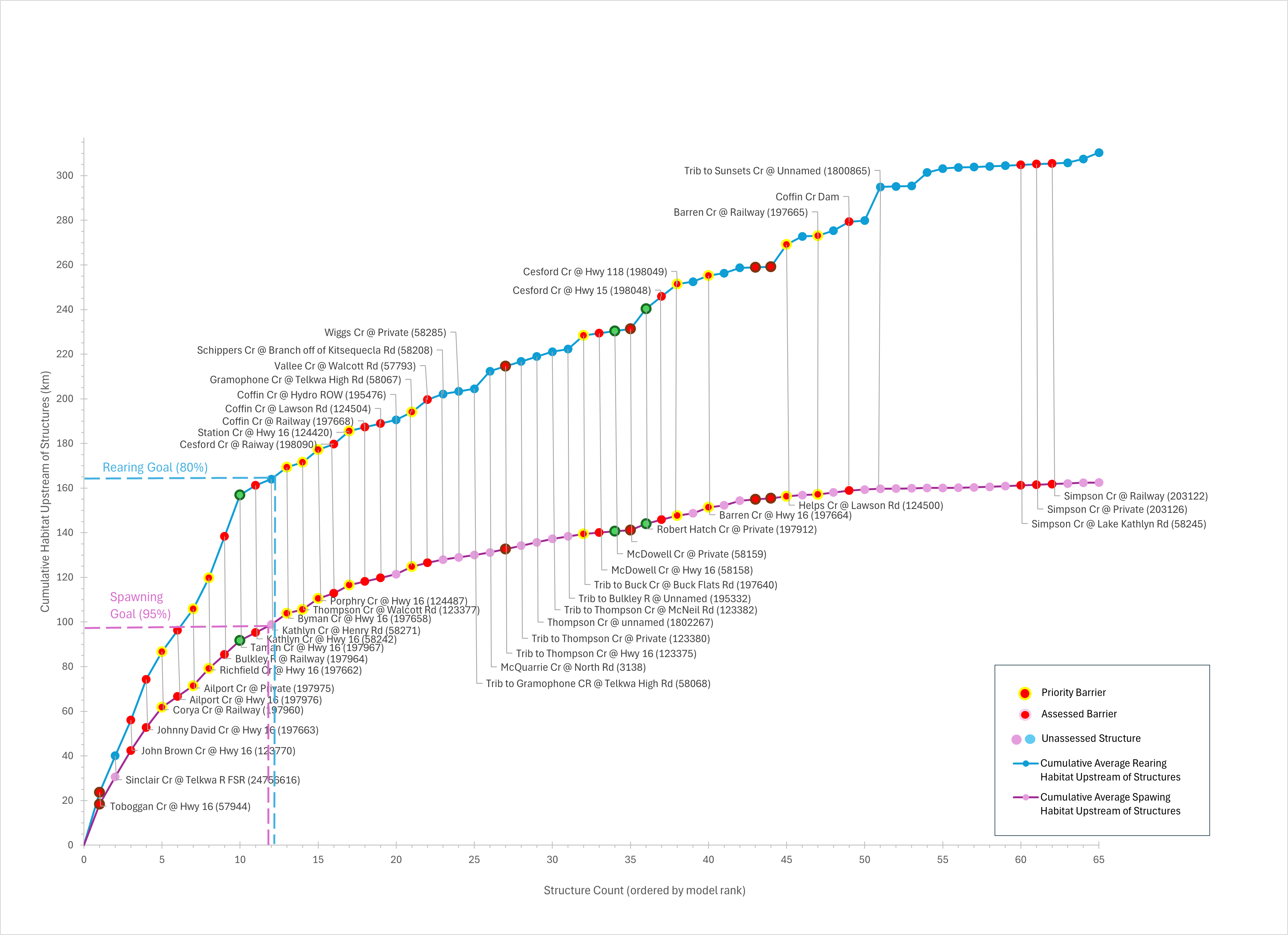
In the Bulkley River watershed, 1175.42 km of Pacific salmon and steelhead spawning habitat are currently connected to the ocean and 154.09 km are disconnected from it. This means that 88.4% of the 1329.5 km of total spawning habitat is connected. In the Bulkley River watershed, 1620.86 km of Pacific salmon and steelhead rearing habitat are currently connected to the ocean and 571.41 km are disconnected from it. This means that 73.9% of the 2192.28 km of total rearing habitat is connected.
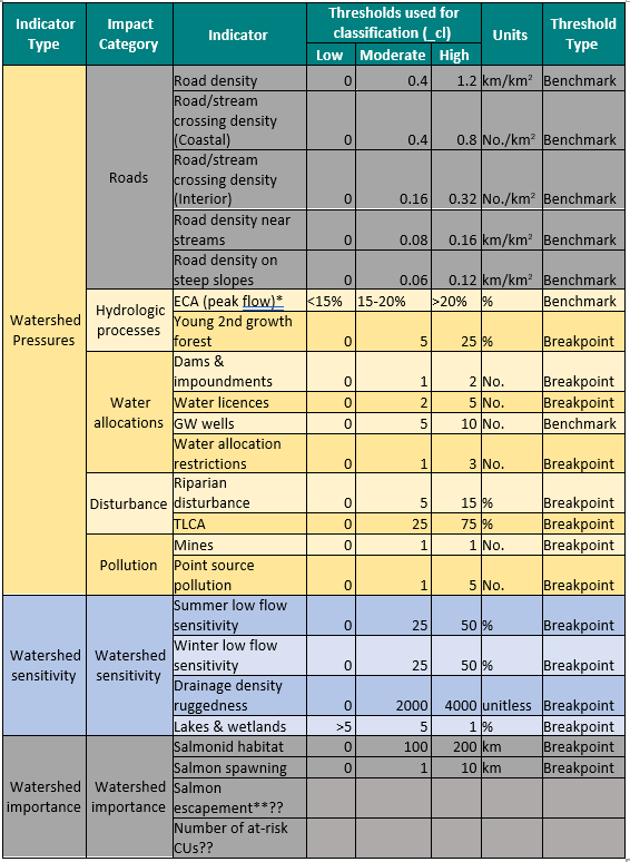 Comments: Indicator rating definitions are based on the consensus decisions of the Planning Team. The current status is based on the connectivity model output, which is current as of May 2026.
Comments: Indicator rating definitions are based on the consensus decisions of the Planning Team. The current status is based on the connectivity model output, which is current as of May 2026.
Goals
Structure Count
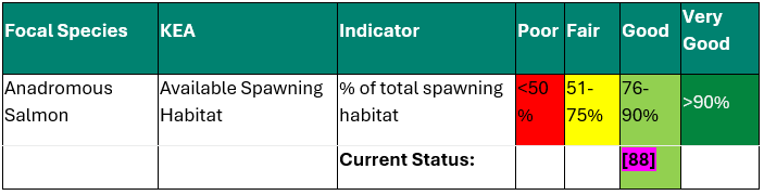
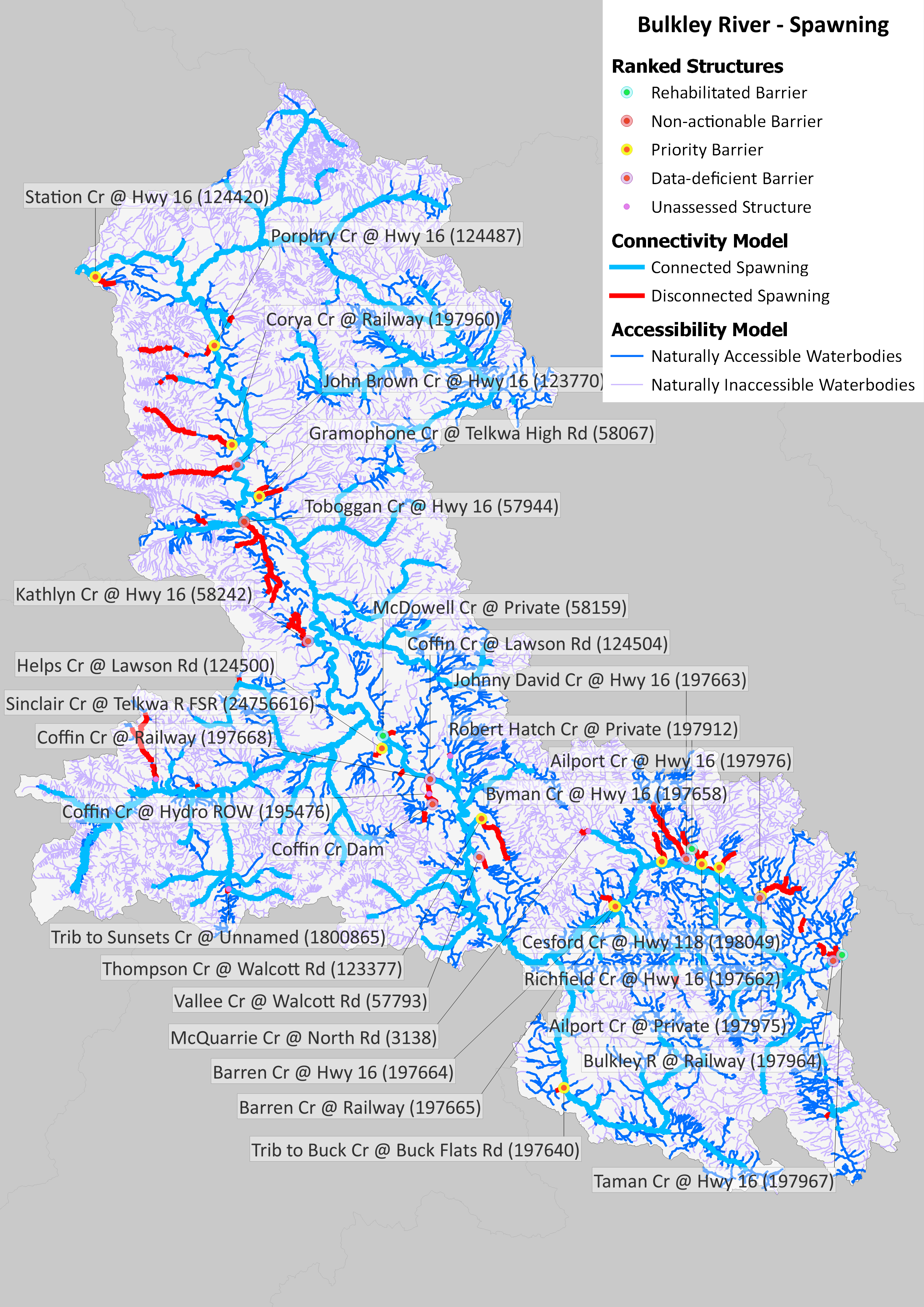
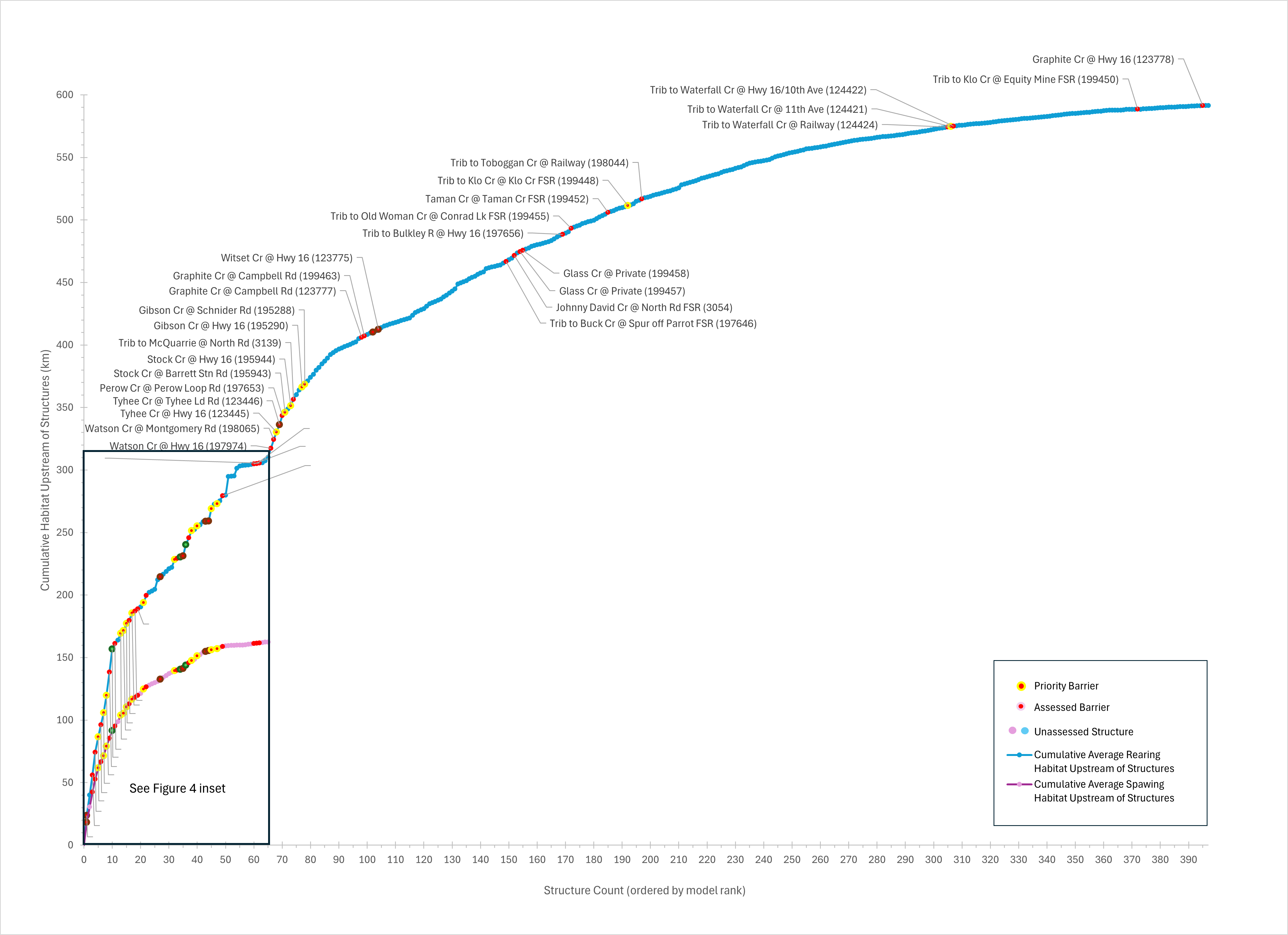
In the Bulkley River watershed, 61 structures potentially disconnect focal species spawning habitat, and 393 structures potentially disconnect focal species rearing habitat. Of these, 20 are identified as barriers in need of rehabilitation (priority barriers), 8 are identified as barriers that do not warrant rehabilitation (non-actionable), and 366 require further field assessment.
Maps
Habitat Accumulation Curves
Habitat Accumulation Summary Table
Weighted Ranks based on Stream Habitat Features
Model ranks vary widely when weighted in favor of either more degraded habitats or relatively intact habitats, relative to the standard CWF ranking structure that takes into consideration only amount (km) of spawning and rearing habitat upstream of a structure. For example, the top 3 structures in the standard CWF ranks for amount of upstream spawning and rearing habitat combined are Toboggan Creek at Highway 16, Bulkley River at rail crossing 197964 and Taman Creek at Highway 16 (paired as rank 2), and Johnny David Creek at Highway 16. When ranks are weighted in favor of relatively disturbed habitats, Toboggan Creek remains the number 1 ranked structure, but Bulkley River and Taman Creek become rank 23. When ranks are weighted towards less disturbed habitats, Toboggan Creek becomes rank 102, with the number 1 ranked structure being Sinclair Creek at Telkwa River Forest Service Road. The top 30 ranked structures using the standard CWF model ranks and their associated spawning, rearing, and weighted ranks are shown in Table 11.
Barrier ID | Internal Name | Structure Status | CWF Model Rank (Spawning) | CWF Model Rank (Rearing) | CWF Model Rank (Spawning & Rearing Combined) | SSAF Rank (Weighted in Favor of Disturbed Habitats) | SSAF Rank (Weighted in Favor of Unisturbed Habitats) |
|---|---|---|---|---|---|---|---|
57944 | Toboggan Cr @ Hwy 16 (57944) | Non-actionable barrier | 1 | 1 | 1 | 1 | 102 |
197964 | Bulkley R @ Railway (197964) | Data-deficient barrier | 8 | 2 | 2 | 23 | 37 |
197967 | Taman Cr @ Hwy 16 (197967) | Rehabilitated barrier | 8 | 2 | 2 | 23 | 37 |
197663 | Johnny David Cr @ Hwy 16 (197663) | Data-deficient barrier | 4 | 3 | 3 | 12 | 58 |
1024756616 | Sinclair Cr @ Telkwa R FSR (24756616) | 2 | 4 | 4 | 117 | 1 | |
123770 | John Brown Cr @ Hwy 16 (123770) | Data-deficient barrier | 3 | 5 | 5 | 118 | 2 |
197976 | Ailport Cr @ Hwy 16 (197976) | Data-deficient barrier | 6 | 6 | 6 | 82 | 7 |
197975 | Ailport Cr @ Private (197975) | Priority barrier | 6 | 6 | 6 | 82 | 7 |
1001800865 | Trib to Sunsets Cr @ Unnamed (1800865) | 38 | 7 | 7 | 102 | 6 | |
197662 | Richfield Cr @ Hwy 16 (197662) | Priority barrier | 7 | 8 | 8 | 34 | 33 |
124500 | Helps Cr @ Lawson Rd (124500) | Priority barrier | 32 | 9 | 9 | 73 | 12 |
197960 | Corya Cr @ Railway (197960) | Priority barrier | 5 | 10 | 10 | 86 | 8 |
197974 | Watson Cr @ Hwy 16 (197974) | Data-deficient barrier | 11 | 11 | 87 | 9 | |
198065 | Watson Cr @ Montgomery Rd (198065) | Data-deficient barrier | 11 | 11 | 87 | 9 | |
58242 | Kathlyn Cr @ Hwy 16 (58242) | Data-deficient barrier | 9 | 14 | 12 | 2 | 104 |
197668 | Coffin Cr @ Railway (197668) | Data-deficient barrier | 15 | 12 | 13 | 60 | 20 |
124504 | Coffin Cr @ Lawson Rd (124504) | Data-deficient barrier | 15 | 12 | 13 | 60 | 20 |
195476 | Coffin Cr @ Hydro ROW (195476) | 15 | 12 | 13 | 60 | 20 | |
1f365462-063c-491e-9fb3-bfac004d9183 | Coffin Cr Dam | Data-deficient barrier | 36 | 12 | 13 | 60 | 20 |
123445 | Tyhee Cr @ Hwy 16 (123445) | Priority barrier | 13 | 14 | 7 | 74 | |
123446 | Tyhee Cr @ Tyhee Ld Rd (123446) | Non-actionable barrier | 13 | 14 | 7 | 74 | |
1001801328 | 40 | 15 | 15 | 8 | 75 | ||
3138 | McQuarrie Cr @ North Rd (3138) | 20 | 16 | 16 | 115 | 4 | |
124420 | Station Cr @ Hwy 16 (124420) | Priority barrier | 14 | 19 | 17 | 63 | 21 |
197653 | Perow Cr @ Perow Loop Rd (197653) | Data-deficient barrier | 17 | 18 | 93 | 10 | |
57793 | Vallee Cr @ Walcott Rd (57793) | Data-deficient barrier | 17 | 18 | 19 | 5 | 96 |
197640 | Trib to Buck Cr @ Buck Flats Rd (197640) | Priority barrier | 23 | 20 | 20 | 13 | 64 |
198090 | Cesford Cr @ Raiway (198090) | Data-deficient barrier | 13 | 21 | 21 | 3 | 108 |
124487 | Porphry Cr @ Hwy 16 (124487) | Priority barrier | 12 | 22 | 22 | 119 | 3 |
197658 | Byman Cr @ Hwy 16 (197658) | Priority barrier | 10 | 23 | 23 | 96 | 11 |
195943 | Stock Cr @ Barrett Stn Rd (195943) | Priority barrier | 24 | 24 | 28 | 41 | |
1001801055 | 24 | 24 | 28 | 41 | |||
195944 | Stock Cr @ Hwy 16 (195944) | Priority barrier | 24 | 24 | 28 | 41 | |
3139 | Trib to McQuarrie @ North Rd (3139) | Data-deficient barrier | 25 | 25 | 116 | 5 | |
123377 | Thompson Cr @ Walcott Rd (123377) | Priority barrier | 11 | 26 | 26 | 11 | 82 |
123375 | Trib to Thompson Cr @ Hwy 16 (123375) | Non-actionable barrier | 21 | 26 | 26 | 11 | 82 |
123380 | Trib to Thompson Cr @ Private (123380) | 21 | 26 | 26 | 11 | 82 | |
1001802267 | Thompson Cr @ unnamed (1802267) | 21 | 26 | 26 | 11 | 82 | |
123382 | Trib to Thompson Cr @ McNeil Rd (123382) | 21 | 26 | 26 | 11 | 82 | |
3091 | 27 | 27 | 68 | 24 | |||
1001800403 | 28 | 28 | 15 | 68 | |||
195290 | Gibson Cr @ Hwy 16 (195290) | Priority barrier | 29 | 29 | 30 | 43 | |
195288 | Gibson Cr @ Schnider Rd (195288) | Priority barrier | 29 | 29 | 30 | 43 | |
1024748047 | 33 | 31 | 30 | 80 | 16 |